
by Gary S. Breschini, Ph.D. and Trudy Haversat, M.A.
Introduction
The Esselen were one of the least numerous groups in California, and are often cited as the first California group to become culturally extinct. Some have placed cultural extinction early as the 1840s (Kroeber 1925:544; Hester 1978:497; Beeler 1978:3). Reasons cited generally include the small size of the group, and close proximity of Esselen territory to two of the three earliest California Missions.
This picture of Esselen extinction, although pervasive in the literature, is wrong. There is recent evidence that some Esselen may have escaped the missions entirely by retreating to the rugged interior mountains. It appears that a small group may have survived into the 1840s before filtering to the ranchos or the outskirts of the growing towns. Although we know of no individuals who claim full-blood status, there are hundreds of people who can document some degree of descent from the Esselen. Some traditions have been passed down from generation to generation.
In spite of recent advances, relatively little is known about many aspects of Esselen culture and prehistory. The following is a brief overview assembled from a number of sources, most of which are included under “Sources” below.
Territory and Geographic Setting
In order to understand the Esselen it is first necessary to place them within the context of their geographic setting. When they were “discovered” by the Spanish over 200 years ago, the Esselen lived in the upper Carmel Valley, in the rugged and densely-forested Santa Lucia Mountains, now a part of the Los Padres National Forest. Much of Esselen territory is now included within the Ventana Wilderness area. (See map.)

The Santa Lucia Mountains are extremely rugged, characterized by jagged peaks and steep canyons. The portion of the coast controlled by the Esselen generally lacks wave-cut terraces; it consists largely of high steep cliffs cut by small coastal creeks. Traveling north and south along the coast would have been extremely difficult. It is most likely that such journies involved traveling inland to the crest of the coast ridge, and then following that ridge north or south.
In studying the Esselen, the nature of the terrain must constantly be kept in mind. The rugged terrain in which they lived contributed to their way of life. Other than the obvious restrictions which the terrain would impose upon their settlement patterns and subsistence strategies, it would have also affected trade and communication with their neighbors, and influenced their lives in a multitude of more subtle ways. For example, the partial isolation of the Esselen probably contributed to the degree of linguistic distinctness noted by Kroeber, as well as the distinctness of Esselen culture.
Political Geography
According to Milliken (1990:59) there were five Esselen districts: Excelen, Eslenahan, Imunahan, Ekheahan, and Aspasniahan (see map). Each of these districts occupied a fairly specific territory with generally-recognized boundaries, and most likely had a reasonably stable resident population. Within each district there were a number of villages which were sequentially occupied on a seasonal basis depending on the availability of resources such as food, water, shelter, and firewood. Of these five districts, the boundaries of the Excelen district are probably the best known. The least known boundaries are in the mountainous areas between Excelen, Imunahan, and Ekheahan.
Population
Kroeber (1925:545) estimated that the Esselen population was between 500 and 1,000, probably closer to 500. Cook initially placed the Esselen population at 750 (1943:186), but subsequently revised his estimate to over 1,300 (1974a:11). Cook’s estimate of at least 1,300 was based partially on the assumption that the Esselen occupied a territory of 625 square miles with a population density of 2.1 individuals per square mile. Cook’s mission record research identified approximately 951 Esselen baptisms, but his figures included Sarhentaruc. Using a multiplication factor 1.5 to account for the difference between the number of baptized individuals and the actual population, Cook arrived at an aboriginal population between 1,300 and 1,425 for the Esselen and Sarhentaruc areas. When Sarhentaruc is removed the population drops to about 1,185.
Milliken (1990) argues that Sarhentaruc should not be included within Esselen territory. Milliken’s baptism counts for the five Esselen districts (excluding Sarhentaruc) included 856 individuals. If, as Cook suggests, a multiplication factor of about 1.5 is applied, a total population of about 1,285 is reached. This is in reasonably close agreement with Cook’s estimates.
Milliken estimates Esselen territory at about 750 square miles (including Sarhentaruc). Our own research suggests that the Esselen controlled an area closer to 775 square miles in size (Breschini and Haversat 2004:67) (excluding Sarhentaruc). Using Milliken’s population estimate of 1,285 yields a population density of about 1.5 or 1.6 persons per square mile. Given the rugged nature of the Esselen territory, this may be a more reasonable figure than Cook’s 2.1 persons per square mile.
To summarize, the actual number of Esselen baptized (excluding the Sargentaruc area) was in the range of 790 (Cook 1974a:11) to 856 (Milliken 1990:28). Recent population estimates based on these numbers range from 1,185 to 1,285.
Linguistic Classification
The Esselen language was originally classified provisionally (along with a number of other languages or language families) as a member of the hypothesized Hokan stock (Dixon and Kroeber 1919:54; Kroeber 1925:544; Hester 1978:496). In the “consensus classification of 1964” linguists suggested that Esselen may be an isolate within the Hokan Phylum (Goddard 1996a:319). Shipley (1978:81), however, noted the possibility that Esselen is the single remnant of a language family that has long since vanished.
Other analyses (cited in Goddard 1996a:319-320) also suggest that neither the Esselen nor the Chumash should be included within Hokan, but rather should be considered isolates. Goddard cites Jacobsen (1979:570), who notes, “The Hokan languages are extremely distantly related to each other, and the proof is really lacking that they are mutually more closely related than some might be to some other languages outside of the conventionally-recognized group.”
There is a considerable body of data suggesting the Esselen or an Esselen-like language was once spoken as far north as the San Francisco Bay area, and that gradually that area was lost to expanding Penutian-speakers (Breschini 1983; Moratto 1984; Shaul 1998:130).
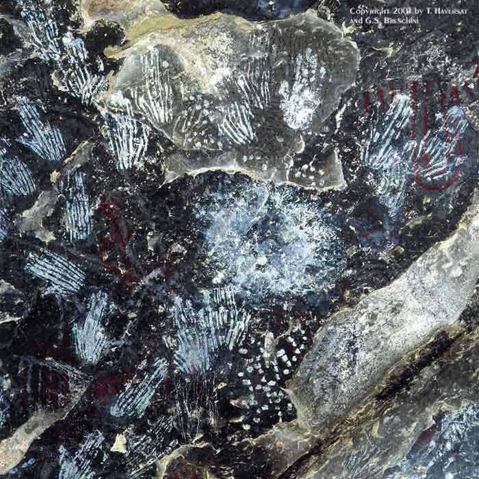
Rock Art
The Esselen are known for the unique handprints which are found primarily in the interior, south of Chews Ridge (see map).

Material Culture
Dress and Personal Ornamentation
In an early account (prior to 1775), the dress of the Indians in and around Monterey and Carmel was described by Pedro Fages as follows:
Nearly all of them go naked, except a few who cover themselves with a small cloak of rabbit or hare skin, which does not fall below the waist. The women wear a short apron of red and white cords twisted and worked as closely as possible, which extends to the knee. Others use the green and dry tule interwoven, and complete their outfit with a deerskin half tanned or entirely untanned, to make wretched underskirts which scarcely serve to indicate the distinction of sex, or to cover their nakedness with sufficient modesty [Priestley 1937:66].
Structures
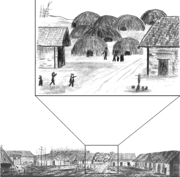
No specific information on Esselen structures has survived. We do have some information from drawings and descriptions at Mission San Carlos, as well as some additional information from archaeological research.
The living structures built by Indians living at Mission San Carlos were mostly located on the slope to the north of the church and quadrangle. A close-up drawing of these, by John Sykes, November 1794, appears below, and clearly shows hemispherical domed structures.
Tools and Weapons
The Esselen manufactured and used a wide variety of artifacts. However, the data on material culture are better represented in archaeological collections than in the ethnographic literature.
The artifacts found at site CA-MNT-44, in the Tassajara area, included bone awls, antler flakers, projectile points (including Desert side-notched points), scrapers, etc. A small sandstone mortar, possibly used in conjunction with a mortar hopper was also found (Breschini 1973). Mortar hoppers were bottomless baskets placed atop stone mortars or stone slabs when pounding acorns and other seeds. During the pounding process, mortar hoppers helped keep the pounded flour from falling out, protected the flour from the wind and kept out debris .
CA-MNT-1601, a small site on the Carmel River, produced projectile points (again including Desert side-notched points), a variety of cores and modified flakes, bone awls, a bone tube, a bone gaming piece, manos and pestles, etc. (Breschini and Haversat 1995). Portable and bedrock (or earthbound) mortars would have been used in conjunction with the pestles, and metates (either portable or earthbound) would have been used in conjunction with the manos. Few metates, however, have been found in Esselen territory.
These archaeological assemblages are generally comparable with other Esselen and Rumsen Costanoan collections from the same time period.
Musical Instruments
The Esselen, and other local groups, did not use the hide drum. They used instead a split “clapper” stick probably made of elderberry. They probably also used flutes or whistles.
Basketry and Cordage
The Esselen and other central California groups did not use pottery; for many of the functions elsewhere served by pottery they used finely-woven baskets.
Unfortunately, as is typical for the Esselen, there is virtually no data available on their basketry practices, and there were thought to be no surviving Esselen baskets. However, a single specimen has recently been identified as either Esselen or Esselen-style. This is described in detail in our recent book on the Esselen (Breschini and Haversat 2004:131-139).
The Mission Era
In Monterey, on June 3, 1770, when the Spanish soldiers established their presidio, or military outpost, and the Franciscan padres founded their mission, the local Indians’ world began to change drastically.
In the fall of 1771, Fr. Junípero Serra relocated the mission from Monterey to Carmel. There were not enough Indians living in the Monterey area to suit Serra, and he wanted to separate the few that he had attracted from the soldiers stationed at the presidio.
In Carmel, the new mission was situated within a short distance of the Rumsen villages of Achasta and Tucutnut, and the missionaries concentrated on the Rumsen. As they expanded their proselytizing outward, the padres encountered the Esselen.
By 1774 one Esselen group, the “Eslen” of the Soledad area, whom Serra had met on the road to Mission San Antonio, had visited Mission San Carlos twice.
The first Esselen to be baptized was the chief of Excelen, Pach-hepas, who, being in danger of death, was baptized in his home village in 1775.
In all, some 900 Esselen were baptized and brought to the missions at Carmel, Soledad, and San Antonio, but the death rate at the missions was high. Births could not keep up with deaths and the population at Mission San Carlos peaked in 1795.
During the Mission Era, under the Spanish and later the Mexican governments, the Indian population of the Monterey area declined by an estimated 90%.
There were a variety of causes for this disastrous population decline, including the heavy labor required to build and maintain Mission San Carlos, unhealthy living conditions and inadequate diet provided by the missionaries, and the total domination and demoralization of an entire people (for additional information see, for example, Jackson 1994; Jackson and Castillo 1995; Cook 1943a, 1943b, 1976; Stodder 1986; Costo and Costo 1987; Walker and Johnson 2003, Sandos 2004).
These conditions made the effects of introduced diseases (including measles, smallpox, and syphilis), for which the Indians had no natural immunity, all the more devastating.
As the missions were disbanded in 1834, and in fact had been nearly powerless for years before that date, it would have been possible for Indians to have moved directly from the remote mountains to the newly settled ranchos, where they could have found employment as vaqueros (cowboys) or servants and lived with relatives who were no longer held at the missions. It is also possible that individuals released by the missions returned to their original homelands. However, because of the growing settlement of the upper Carmel Valley and adjacent mountains during the early American era, it is doubtful that any sizeable number of unbaptized Indians survived even in the remotest mountains after the 1850s, although perhaps a few individuals could have held out a little longer.
Summary
This brief overview of the Esselen is not designed to be detailed, but rather to serve as the briefest of introductions. For a much more detailed look at the Esselen, see our book The Esselen Indians of the Big Sur Country: The Land and the People (Coyote Press, 2004).
Copyright 2001-2005 by G.S. Breschini and T. Haversat
All Rights Reserved.
Website:
- Visit the Esselen Tribe’s website. (Link updated 11-2023)